Portland adds residents and daily services, reuses viable buildings, protects affordable space and connects distinctive neighborhoods with excellent streets and transit
2045 VISION A BLOCK-BY-BLOCK FUTURE
What if downtown
worked for everyone?
Explore what exists today, what each building and block could become, and the coordinated moves needed to create the world’s most livable small city center.
01 / EXPLORE DOWNTOWN
Every area. Every block.
Official zoning, parcels and buildings form the base. Fifteen smaller areas explain what is working, what is not and what should change.
Choose a place on the map or browse the property list
Map key Today · Office + Civic Core
What is physically here today
Building colors show the broad use recorded by the City. Green shapes are official parks. Roads, transit and place names belong to the background map.
Active area: Office + Civic CoreA soft lime wash marks the downtown area currently open. Streets remain visible between its blocks. This is a navigation cue—not a parcel status, recommendation or ownership boundary.
Assessor parcel boundariesThin blue lines divide official taxlots. A parcel is not always the same thing as one physical building.
HomesLavender marks a building recorded as single-family or multi-family residential.
Hotel or visitor lodgingA building recorded as a commercial hotel—not an office building.
Civic, cultural or institutionalPublic, educational, religious, cultural or other institutional space.
Industrial or productive spaceA building recorded for industrial, warehouse or production-related use.
Parking or vacant recordA building record associated with parking or a parcel recorded as vacant. This does not prove the site is currently unused.
Other commercial or use not recordedOffice, retail, restaurant, general commercial or a building whose more specific use is not recorded.
Official park or open spaceGreen marks a City-recorded park boundary. Click it for its available amenity and public-realm record.
Recorded use is not occupancy. A dark building may contain offices, shops, restaurants or another commercial use; it is not necessarily empty or available.
Official-data snapshot: Loading · zoning, parcels, buildings, BLI capacity, parks, permits, projects, transportation and equity.Portland Possible: recommendations and the 15-area theory are proposals, kept separate from recorded facts and official models.See Portland’s open-data catalog ↗
00 / THE CITYWIDE PLANOne promise.
One promise.
Eight outcomes.
A compact center where people with different incomes can live, work, make things, learn, gather and reach daily needs without organizing life around a car or a nine-to-five office schedule.
downtown can support ordinary life all week while remaining the region’s center for jobs, culture, government and visitors
many different users, times of day and neighborhood economies make the center more useful and less dependent on any single market.
PROPOSED 2045 CITY-CENTER SCORECARD
These are this project’s starting targets for public debate—not adopted City policy. Each neighborhood, block and building should show which outcomes it advances and what would be measured.
01
Enough residents for ordinary life
People can find homes for different incomes, ages and household sizes—and downtown businesses gain dependable customers.
Target + measure+
- Proposed 2045 target
- 30,000 additional Central City homes by 2045; at least 30% permanently affordable and 25% suitable for families
- Track
- Homes, affordability term, bedrooms, resident-origin trips
02
A productive downtown economy
People can find offices, studios, research, education, repair and production work—not only consumption and entertainment.
Target + measure+
- Proposed 2045 target
- Return at least 6 million square feet of persistent vacancy to useful activity while protecting core production districts
- Track
- Occupied floors, jobs, small tenants, protected production space
03
Daily life within reach
Groceries, childcare, healthcare, schools, recreation and inexpensive gathering places are close and open when residents need them.
Target + measure+
- Proposed 2045 target
- Every downtown resident can reach a complete set of daily needs within a safe 15-minute walk
- Track
- Service gaps, opening hours, price points, walking access
04
Useful beyond nine-to-five
Streets and buildings feel inhabited in the morning, workday, evening and weekend without relying on constant festivals.
Target + measure+
- Proposed 2045 target
- Every area has at least three strong activity periods and every priority block has a public-facing use after 6 p.m.
- Track
- Visits and occupied floors by time of day
05
Permanent room for people who create value
Residents, artists, makers, venues and small businesses are not temporary placeholders for a more expensive future.
Target + measure+
- Proposed 2045 target
- Protect at least 1 million square feet of creative, cultural, production and useful storefront space for the long term
- Track
- Protected square feet, rent burden, tenant retention
06
One connected public realm
A person of any age or ability can move safely between transit, parks, institutions, neighborhoods and the river.
Target + measure+
- Proposed 2045 target
- Close every dangerous gap on the civic, river and neighborhood spine network; make 70% of Central City trips by walking, biking or transit
- Track
- Continuous safe-route miles, crossings, mode share, time spent
07
Reuse and resilience first
Portland keeps useful buildings, improves earthquake safety and spends carbon and public money where they create lasting value.
Target + measure+
- Proposed 2045 target
- Every priority building receives a retain, reuse, convert or replace decision backed by seismic, carbon and cost evidence
- Track
- Disposition plans, embodied carbon, energy and seismic work
08
A center that remains Portland
Historic buildings, independent businesses, cultural production, public institutions and the river remain visible and useful.
Target + measure+
- Proposed 2045 target
- No net loss of protected cultural anchors; every neighborhood has a funded steward and a distinct public role
- Track
- Anchors retained, local ownership, public programs, stewardship funding
Swipe to explore all eight outcomes →
EVERY RECOMMENDATION MUST TRACE THROUGH
CITY GOAL→NEIGHBORHOOD ROLE→BLOCK JOB→BUILDING MOVE→MEASURED RESULT
02 / FOUR LENSES
Start wide. Get specific.
CITY
Set the outcomes every investment must advance
Eight goals + one scorecardNEIGHBORHOOD
Give each of fifteen areas a distinct promise and role
People + portfolio + connectionsBLOCK
Assign different blocks complementary jobs
Ground floors + upper floors + streetsBUILDING
Choose one realistic contribution and explain why
Keep + reuse + convert + replace03 / FIFTEEN REAL PLACES, POSSIBLE FUTURESAn arrival point becomes
An arrival point becomes
a city neighborhood.
Union Station + Broadway
Portland's front door should feel like the beginning of the city—not an island surrounded by roads and parking. The station stays the landmark while new homes, transit and public life gather around it.
01 of 15
Station Arrival Use the arrows to move through all fifteen places, or open the list to jump directly to one.
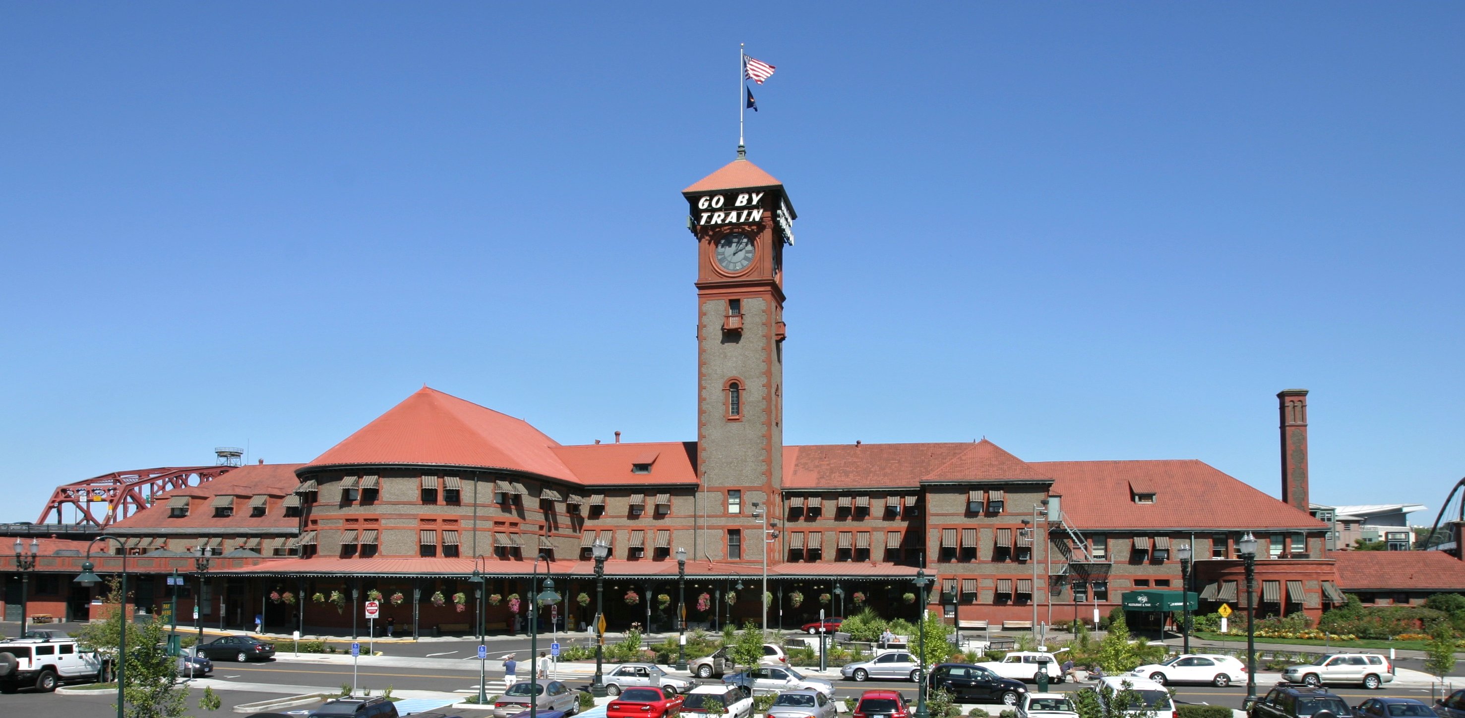 POSSIBLE FUTURE · 2045BEFORE · 2005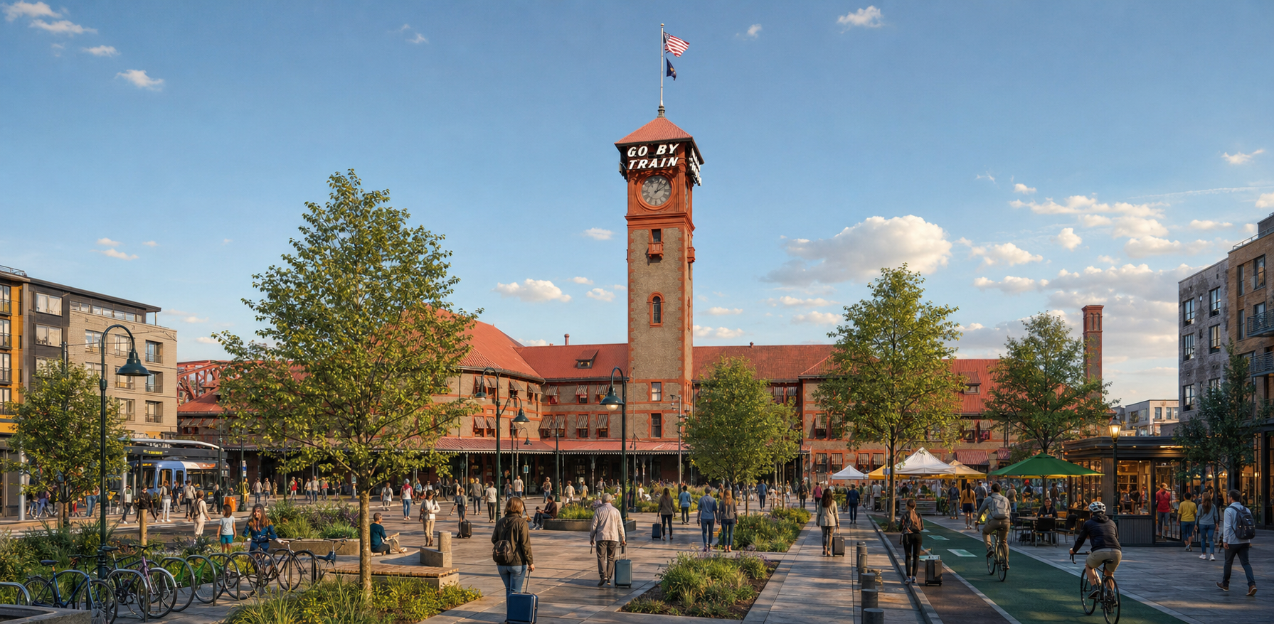
DRAG TO COMPARE
Pull the divider—or focus it and use the arrow keys—to reveal more of the possible future.
WHY THIS VIEW
The station, parking and arrival lanes show why Portland's landmark still feels separated from the city around it.
WHAT VISIBLY CHANGED
- A real civic arrival plaza replaces leftover vehicle space
- Homes and active ground floors frame the station without hiding it
- Walking, transit, cycling and drop-off each get a clear route
A great landmark, stranded
- Roads and parking make the station feel separated from downtown
- The walk toward Old Town and the Pearl is confusing and exposed
Show 2 more +
- Large nearby sites produce little daily street life
- Travelers arrive at a station, but not yet at a complete neighborhood
Build Portland's front door
- Create a generous arrival plaza with trees, seating and weather protection
- Give buses, bikes, walking and drop-off traffic their own clear space
Show 2 more +
- Add mixed-income homes and flexible workspaces around—not over—the station
- Line the route south with small shops, food, services and many doors
A gateway that stays useful
- Travelers step directly into a welcoming piece of Portland
- Residents keep local businesses active between train arrivals
Show 2 more +
- The station becomes an easy walk to Old Town, the Pearl and the river
- A civic landmark anchors growth instead of being swallowed by it
Swipe to compare what exists, what changes and what people gain →
04 / BUILD A STRATEGY
See why the moves have to work together.
Turn strategies on and off. The panel shows which downtown problems your package addresses compared with today—not a made-up forecast of an exact percentage or number of square feet.
Observed TODAY'S STARTING POINT
No strategy selected yet.
The switches are all off, so nothing below is being presented as an improvement. These are the current conditions the strategy is meant to change.
05 / LESSONS FROM OTHER CITIES
Borrow what actually works.
Portland should not copy another city’s look. It should borrow the rules, funding tools and public services that keep great downtowns useful, adaptable and welcoming.
01
TOKYO
Use every floorRail brings people close; small spaces and flexible floors help buildings stay useful as needs change.
→02MELBOURNE
Turn leftover spaces into placesAlleys, universities, homes, culture and offices work as one connected downtown.
→03PARIS
Make daily life localEnough nearby residents keep useful shops and services busy every day.
→04COPENHAGEN
Treat streets as public roomsWalking, biking and transit leave more street space for people to meet, rest and linger.
→05VIENNA
Protect who gets to stayLong-term affordable housing and workspaces keep success from pushing people out.
→Swipe to compare all five city lessons →
SEE WHAT PORTLAND COULD ADOPTFive cities · twenty specific actions →06 / WHAT PORTLAND MUST CHANGE
Design is only half the plan.
ZONING
Allow different compatible uses on different floors, and permit housing where it will not displace essential jobs.
BUILDING RULES + PERMITS
Create one clear path for reusing old buildings while keeping earthquake, fire and accessibility standards strong.
FUNDING
Use conversion loans, tax incentives and public purchases only when projects deliver clear public benefits.
LONG-TERM OWNERSHIP
Use land trusts, cooperatives and nonprofit ownership to keep key spaces affordable before prices rise.
STREETS
Plan deliveries, buses and trains, bikes, events and walking space together instead of one at a time.
07 / KNOW WHAT IS FACT AND WHAT IS A PROPOSAL
Ambition without pretending.
Every claim should show whether it is a known fact, an estimate or a proposed future—and where it came from. That lets Portland imagine boldly without presenting a rendering as reality.
What records tell us today
Official parcel, zoning, permit, energy and assessor records, plus market data and on-site checks. Public records can be incomplete, so gaps are shown.
What the evidence suggests could work
Estimates of how much space could fit, which buildings may convert, what it may cost and how many people might use it. The assumptions stay visible.
What this project proposes
Generated images, design ideas, policy changes and desired results. These are possibilities, not approved projects.
WHERE THE NUMBERS COME FROM / AUGUST 2026
Start with public evidence.
Portland already has
the bones.
The work is to decide, building by building and block by block, what should stay, what should change and who the change should serve.
Return to the atlas ↑